|
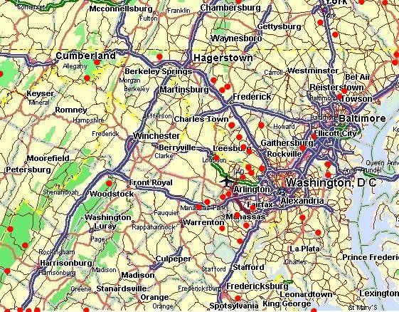
The map below shows the location of MTB Trails in DC area,
MTB Links For more information on MTB Trails, check out the MTBR Site. Think to upgrade bike? See online catalogs at |
| You are visitor # : | ||
|
|
||
Accident
(Deep Creek Lake)
Length: 10 Mi
Singletrack. Excellent tight single track with lots of fast rocky sections as well as moderate amounts of climbing.
Dir::Off of route 219 in Accident Maryland. The trails are in Savage River State forest. Best bet is to contact High Moutain Sports in Deep Creek.
Green Ridge State Forest
Length: 12 MiSignal track in some spots. Good hills, pretty challenging up hills, fast down hills. Nice state park.
Dir: From DC/Balt: route 70 to route 68. Exit #62 to route 144 west. Drive about 3 miles follow the signs.
Flintstone
Length: 100-150 MiAll the trails are very hilly, pretty fast, little rocky, some very, very steep, some kinda easy, most are fast double track, long climbs, extreme riding, but very very fun.
Dir: Take I-68 west to Flintstone, MD. Greenridge State Forest.
Whitetail Ski Resort
Length: 12 MiThe ski resort gives novices and folks who only ride on paved roads and bike paths a chance to try out their mountain bikes where they were meant to be ridden--on a mountain.
Dir: Take I-70 to Exit 18 (Clear Spring) and MD 68 north to the intersection with US 40. Cross US 40 onto Mill Street and drive north to the stop sign, turn right on Broadfording Road and drive a half-mile. Then turn left on Blairs Valley Road and go 5 miles to the resort entrance.
Greenbrier State Park
Length: 6 MiRocky,not as much as gambrill,some good steep climbs,nice armburning down hills,one creek crossing.
Dir: 40west out of Frederick,past Gambrill,cross over A.T.trail,look for signs,park entrance on left.2-3.00 dollar fee.
The Watershed
Length: 2-15 MiMostly Tech. A few good down hills. Some fire trails. Mostly single track. This area offers it all.
Dir: Go up and past Gambrill state park. Follow main road and make your 1st right onto Hamburg Rd. Follow that about 200 yds or so and it's your 1st parking area on the right.
Gambrill State Park
Length: 10-20 MiArea is very technical, rocky and on a mountain top Red Trail, Short lots of speed bumps Yellow Trail, Great single track Black Trail, Harder then the yellow White Trail, walking only.
Dir: From DC 270 North to Frederick to 70 West. At 1st exit (Alt 40) turn right. Left turn onto 40 three miles later. Gambrill Park RD is 7-10 miles up on right.
Elizabeth Furnace
Length: 10-20 MiVery nice variety of fire roads, tight twisty single track, creek crossings and everything else.
Dir: take exit 6 on route 66. go south (i believe this is rt 340)... go about 2 miles, then take a right on rt. 55. go about 5 miles or so, the make a left onto rt 678. follow this route appx 8.5 miles. make a right onto rt 771. this road forks twice, stay to the right both times.
Fire Roads from Hell
Length: >30 Mitrails go for miles on miles u can be out there for 7 hours and not cross back...single track double track fire roads its all here...nasty jumps, sweet downhills
Dir: Take 27 north out of Damascus. The see mtbr.com...
Sugarloaf Mountain
Length: >12 MiBlue trail is 5 miles and yellow is 7 miles. Two stream crossings, some logs, some hills. NO BIKING ON THE WEEKENDS AND OCT 31 TRU MAY 1! Dir: 270 30 miles north of D.C. or 8 miles south of Frederick, take route 109 south for 3 miles, to route 95 turn, right(follow the signs) keep going until the large intersection, the entrance will be on the far right side, you can parck there or at the top.
Shenandoa Mountain
Length: >5-60 MiShenandoah mountain is not a trail, it's an experience!
Dir: all over. check individual reviews.
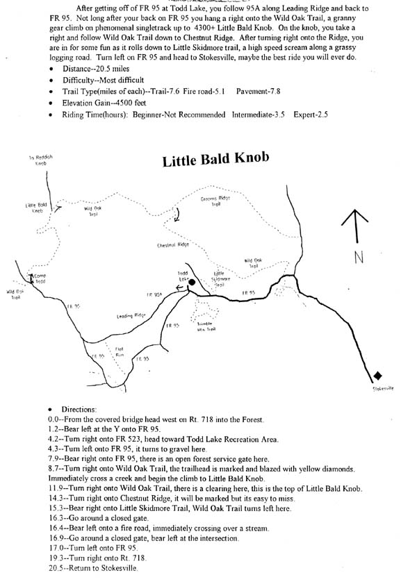
Little Bald Knob
Length: >16 MiThis is a great ride that can be turned into an all-day epic kind of experience if you pace yourself and stop to enjoy the scenery. An overall elevation gain of 4500 feet
Dir: From Dayton, drive west on 257 for a few miles and enter the George Washington National Forest. 257 turns into Briery Branch Rd. See mtbr.com
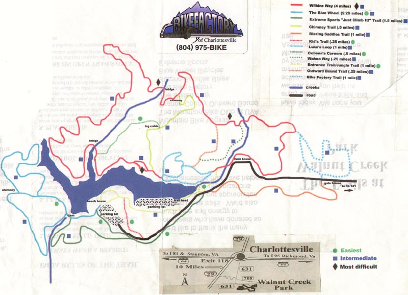
Wintergreen Resort
Length: >6 MiAn eloborate network of single track trails throught a forested landscape. Many small tight loops of varying difficulty.
Dir: South of map position, West from Charlottesville I-64 to the Crozet exit, left on Rt 250 aprox 6 miles, left on Rt 151 aprox 15 miles, right on Rt 664 to Wintergreen Resort Gate House.
Conway Robinson State Forest
Length: >4 MiRight now the trails are under construction. M.O.R.E. is working with the Virginia Department of Forestry to get new trails opened up for us.
Dir: R66 to exit 43(29n) Follow 29n for about 1/2 mile and the park will be on the left
Centreville Power Lines
Length: >8 MiMostly single track. Some pavement to complete the loop.
Dir: Rt. 28 towards Manassas, Rt on Braddock after movie theater, left at first light, go .5 miles to Mount Olive Babtist Church and park there. Head East along the powerlines.
Cedarville State Forest
Length: 8 MiNice trails for good riding and gets you up to speed for more technical trails.
Dir: From 495 take Rt. 5 to Waldorf. Hang a left at Cedarville Road, go a few miles, enter gate then park at office.
Loch Raven
Length:15+MiMostly smooth, hilly terrain. much of it is double track, with scattered singletrack. some roots and rocks, but generally on the easier side.
Dir: Baltimore beltway (695) north towards Towson, take Delaney Valley Rd north. go approx. 4 miles.
Dulaney Valley Loop
Length:10 MiSingletrack & Fire Roads
Dir: 495 to Dulaney Valley North. Pass the parking spot for the Seminary Trail at Seminary Rd. and keep going. Just before a big bridge over the reservoir, park on the left.
The Pits
Length:x MiMoto trails; mostly windy singletrack thru the woods, a tunnel under 95, some fast double track and DS.
Dir: From 495 Cap. Beltway take 95 N. exit towards Baltimore. Exit on 198 Burtonsville (West). Go to the first intersection -lft. on Sweitzer. Rt. on Frost.
Susquehanna River
Length:18 MiRolling single track along river and extreme climbs and downhill sections on Susquehanna Ridge trail. There are few stream crossings, rocky sections and killer steep switchbacks.
Dir: I-95 to Havre De Grace exit #89 RT.155, proceed towards Havre De Grace approx 1/4 mile to Lapidum Rd. take a left on Lapidum Rd. and continue to river, road goes directly to river and boat ramp, continue left along river to Susquehanna State Park historical area(Rock Run MILL) parking is available here
Avalon
Length:20+MiFairly rooty, many stream crossings, lotsa smooth fast singletrack. crowded! some fun technical, but mostly fast and smooth.
Dir: I-95 to Rte 166 west (toward UMBC & Catonsville) Follow signs to the park-n-ride.
Lookout Mountain
Length:13 MiThe ride is a loop near the Todd Lake Recreation area that begins with an easy and very beautiful 4 miles along the North River Gorge trail then climbing 900 feet to the very difficult and technical Lookout Mountain trail, which also has 9 river crossings.
Dir: Exit off I 81 onto 250 West (Staunton), which is the first exit on 81. Follow 250 west for 11 miles then to Rt 42, follow 7.5 miles to Rt 731, then for about 3 mi to 730 and make a left to Stokesville. For further ref. see mtbr review directions.
Worthington Farm Trail
Length:3.5 MiThis trail is part of the Monocacy National Battlefield.(Civil War).It is called the Worthington Farm Trail. It follows the Monocacy River. There are 2 loops. Brooks Hill Loop is 1.9 mi. The Worthington-McKinney Ford Loop is 1.6 mi.
Dir: take 355 from urbana going toward frederick take a left on araby chruch road continue until u hit Baker Valley road take it until you go under the 270 bridge then 6 feet after the bridge take a right into gravel parking lot.
Cosca Park
Length:5-9MiShort, ups and downs, around a lake and over some power lines. Close to D.C. though.
Dir: Take Branch Ave (Rt 5) south. Exit onto Woodyard road west. Turn left onto Brandywine (@ intersection with B.K. Miller Liquors). Turn right on Thrift and mosey on down until you see the softball fields. Park there.
Burke Lake
Length:7.3MiRating:easy Terrain: Flat,asphalt, dirt trails other uses: Hiking, nature observance, picnic, marina, boat launching, fishing.
Dir: Capitol Beltway take 95 south towards Richmond. Take exit 55, Route 644 West(Old Keene Mill Road).Follow Old Keene Mill Road west 3 miles, then turnn LEFT on Huntsman Blvd. Follow Hunstman Blvd. 1.5 miles to Fairfax County Parkway. Turn right on Fairfax County Parkway, go about 0.3 miles and turn left into South Run District Park.
Fountainhead Park
Length:4.5Mivery rooty, mostly singletrack. Terrain is moderately technical, with some short steep climbs, hairpin turns, and a fast downhill section with multiple dropoffs. Great view of Occoquan Reservoir through the trees!
Dir: from 95 S: Take the Lorton exit west, follow Lorton Rd until it ends at Ox Rd. Turn right and travel about 2 mi. to a left turn on Hampton Rd. Fountainhead Park entrance is about 5 miles down Hampton Rd on the left. Trail begins across from the park parking lot.
Arundel High School
Length:8+ MiLong and short climbs, creek crossings, well groomed single track with many loops. Beginner.
Dir: MD175 towards Arundel High School, East from 3, West from 295/BW Parkway. Trails are just beyond sports fields behind the school.
Fran Uhler Natural Area
Length:4-5MiLots of wash outs, mud. Some trails are overgrown with veg. Single track along Patuxent River is tight and muddy. Beginner.
Dir: From Wash. D.C., take B/W Parkway to Rte 197 South towards Bowie. Take left at Lemon's Bridge Rd. Park at MARC train Parking lot. Ride to end of LemonsBridge Rd. Go under RR tracks near Patuxent River and Follow trails behind Bowie State Univ.
Schaeffer Farms
Length:9+ MiThere are two main loops (see map on this site site). A couple of serious dips, and lots of log jumps make this a really challenging trail.
Dir: Take Rt 270 to Rt 118W(ex15), travel on it for approx 2 mi; turn right onto Rt117W (Clopper Rd). Immediately (a hundred feet or so) turn left onto Schaeffer Rd; after approx 2 mi, pass soccer fields, another half mile and turn left at 14938 Schaeffer Rd , there are signs for Grey Rock Ranch. Take the left fork - a downhill road to the new paved parking lot.
Cabin John Trail
Length: 7 MiLots of fun, little technical parts, no sustained climbs, a good place for beginners to learn and experienced riders to take an easy day.
Dir: One of the places is on river road after seven locks road( coming from DC) also you can get on at cabin John ice skating, near Montgomery mall.
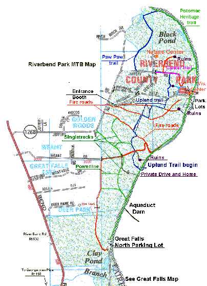
River Bend Park
Length:12 MiThere is a very good trail system in the center of the park . there is a bunch of trails you can do out about 7 miles from the parking lot. Have confidence in the trails they are not too well traveled but they dont just end. Intermediate.
Dir: Take georgetown pike from the beltway. take that out past Medera school and out past old diminion then take a right on riverbend road and a right again on jeffery road.the park is on th right.
Great Falls Park VA
Length:10 MiThis is a great trail network for beginner to intermediate, but the experienced biker will be quickly bored with the technical level. You can put together a loop into River Bend that is 10-15 miles long that is reasonably fun.
Dir: From 495 take the Georgetown Pike exit to Great Falls (west). The park entrance will be on your right after about 4 to 5 miles. The entrance is on the corner of Georgetown Pike and Old Dominion drive.
Difficult Run Colvin Run
Length:9 MiFrom Reston Colvin Run (also see Rt.7 to Reston) then Difficult Run. It is all singletrack but it follows a creek and, thus, it is completely flat. It requires some navigational skills since it crosses a few roads before reaching Lake Fairfax in Reston.
Dir: Take Dulles Toll Road and Exit on Wiehle Ave, right on Sunset Hills and take a right on Michael Farraday, follow the road and bare right, park on the empty lot accross the skating rink.
Rocky Ridge County Park
Length:14 MiThis park offers the best of just about any trail. From smooth downhills on single track testing your turning abilities through sand, mud and gravel as well as killer straight downhills over jagged rocks. A must for any rider with some training, wouldn't recommend it to the faint of heart.
Dir: From York off Rt. 30, take Mt. Zion Rd. (Rt.24) north for 1 mile. Turn right onto Deininger Rd. and follow into park.
Lake Redman
Length:15 MiYou can end up on some of the most impassable single track imagineable, or you can just cruise around for a half hour with the kids.
Dir: Exit 4 off of Interstate 83 go west thru 2 lights,left turn at the second light.(George St.)Go south on George St until you get to the town of Jacobus make a left turn at the flower shop(there are signs for the park at this intersection)go about 1/2 mile and the park is on the left.Stop at the boat dock area
Spring Valley County Park
Length:10 Mimostly singletrack,hard and easy climbs and roots ,rocks,trees,some wild downhills. Dirt roads for beginners and tecknical trails for advanced.
Dir: From I83 Exit 2 travel east on Rt 216 1/10 of a mile, turn right onto Potosi Rd., travel 2 miles To T intersection, turn left, travel 1/4 mile to parking lot at the center of the park.
Dark Hollow
Length:10-30 MiThere are plenty of rocks, uphills, and singletrack you can barely get a bar through. Not for beginners.
Dir: The Start/Finish is at Big Flat Parking Area off the Shippensburg Road several miles west of PA 233.
Lancaster County Park
Length:10 MiFast single track along the river, technical climb back up the hill to fast single track with some trees along the top of the hill. Many different trails to tackle.
Dir: County Park, on the south end of Lancaster, just east of Route 222. From Route 222 take Golf Road (east from 222) From South Duke Street take Williamson Road (west).
Alex's Back Yard
Length: x MiExtreme, the biggest and sickest MTB jumps around
Dir: I 495 TO BRADDOCK ROAD WEST. 1 1/2 MILES TAKE A LEFT ONTO SOUTHAMPTON DR. 1 1/2 MILES TAKE A LEFT ONTO CLYDESDALE. ABOUT 100 YARDS YOU WILL SEE POWERLINES. TRAILHEAD IS ON THE RIGHT AT TOP OF THE HILL. LOOK FOR HUGE JUMPS 50 YARDS ON RIGHT.
Balls Bluff
Length: x MiClosed to MTB, See MTBR Postings.
Dir: From DC...7 west towards Leesburg. take 15 south about a mile. follow signs on left to park.
Hollywood Farms
Length: 9 MiExtrememly tight single track, hilly and technical.
Dir: Take rt 3 west from Fredburg to Hollywood Farms Rd (just before King George line) on left. Approx. 2 miles to dirt road on right just after rail road tracks.
Hidden trail
Length: x MiIt's a great hidden spot, and in one area near the top, there are remnants of a decent BMX park.
Dir: Chantilly, near 50 rt between Lee's Corner Road and Stringfellow Road, see MTBR for full description
Lookout Mountain
Length:13 MiIt climbs and descends on some very rocky, technical singletrack along the ridge of Lookout Mountain.
Dir: Staunton, South of map position, Exit off I 81 onto 250 West (Staunton), which is the first exit on 81. Follow 250 west for 11 miles to Route 42. Make a right onto 42 and go 7.5 miles to Route 731, see MTBR.
North Mountain Trail
Length:20 MiAdvanced,This trail was rated #1 in the State of Va by Outside magazine, definitely a winner for southern Va!!!
Dir: Lexington, South of map position, From Lexington take 64 west(about 15min) to Longdale Furnace exit. Hang a left and go just under a half mile to the first left. It's almost like a u-turn but it is a paved road with some houses scattered. After a short bit it becomes gravel and you are in the park.
PedroPlutoPintoPablo Trail
Length: 5 MiBeginner, Its some SIC powerline trails, Singletrack & Fire Roads
Dir: Its right by potomac mills mall.
Panorama Farm
Length:20+MiIntermediate, call 804.974.7849 to check if open, This is absolute favorite place to ride. The trails are in great condition and beautifully laid out to match the land.
Dir: South of map position, from Charlottesville from 29N take a left onto Rio Rd., 1/2 mile take a left at The Rock Store onto Earlysville Rd., after a couple miles, take a left onto Panorama Fram Rd. Follow that gravel road to a right into the Panorama Farm parking, there's a bulletin board there. This is private property and there is a donation box so hook it up.
Panorama Farm
Length:60+MiAdvanced, The terrain varies in this trail system from small rocks to large rocks. Cross 4-5 creeks.DO NOT ATTEMPT WITHOUT A MAP AND PLENTY OF FOOD/WATER/TOOLS.
Dir: South of map position, From Richmond - Take I64 west to Afton (exit 96). Go left once you come to the stop sign (Rt. 624). Take this to Rt. 664 (It is really just a curve in the road near a nusery). Continue on until you come to Fire Road 42 (It might be named "Coal Rd."). Turn right and follow the gravel road. You can park in the open area about a 1/2 mile on the left.
Signal Hill Trail
Length:5.3 MiBeginner, Pawed, Relaxing.
Dir: Manassas Park
Sinclair mills
Length:20 MiThis network of motocross trails would be fun to ride if there were not so many yellow no trespassing signs.
Dir: Take Rt 66 W to Rt 234. Take Rt 234 through Manassas and make a right on Sinclair Mills Road. Go about 1.5 miles and the trailhead is on the left.
York River State Park
Length:3-6 MiSeveral different trails ranging from easy to intermediate. Fun for racing.
Dir: South-East off Richmond (not on map position) From I-64 to croaker exit 231B and bare right off the exit and follow that road about 1.5 miles to Moss side lane and take a right, at the end of Moss Lane take a right and follow the road to York River State Park.
Fair Hill County Park
Length:60+MiTrails for all skill levels, some are technical, the workout is always good, the scenery is great.
Dir: North-East MD (not on map position). I-95 ex.107(?) to 213 North, right to Md 273, go about one mile east on Md 273, past the Fair Hill Fairgrounds and turn right on Kennel Road. Go 1/2 mile to first intersection and park in lot on right. On bike, cross Kennel road (to east side) and head downhill on one of the many trails.
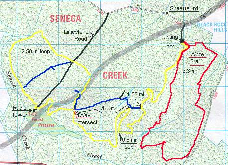
Seneca Creek State Park
Length: 7 MiRooty singletrack with minimal climbs. Some logs.
Dir: Gaithersburg,Clopper Lake,I-270 to Clopper Rd (117) West. Follow for approximately two miles to the park gates on the left.